 简体中文
简体中文 English
 繁体中文
繁体中文

Northern Xinjiang road 19 days tour
{{item.d}}
¥{{form[item.str].price || 0}}
剩余:{{form[item.str].total || 0}}
Overview of itinerary
Product Manager recommendation
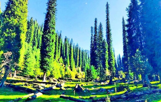
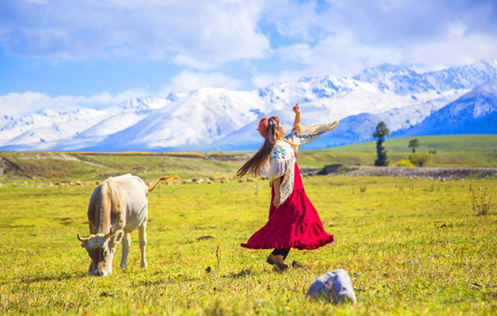
Northern Xinjiang is flat and has a humid climate.We will spend 19 days with you to enjoy the natural scenery of northern Xinjiang! See the snow-capped mountains reflected in Tianchi,feel the passion of the grassland,explore the mystery of Kanas Lake,and drive on the Duku Highway to feel free!
Highlights
● Into Yili ,Liuxing Street has witnessed the strange cultural symbiosis phenomenon of the combination of foreign culture and local culture.
● You can take photos and punch in the Sayram Lake scenic area,stop and enjoy the leisurely time.
● Travel to the Cocotosea Scenic Area and discover the secrets of the Irtysh River.
● Stand next to the rippling Kanas Lake and look for signs of the Kanas Monster.
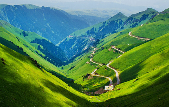
● Enter the world's most beautiful grassland - Naraty grassland,free yourself on the grassland!
Travel overview
Detailed itinerary
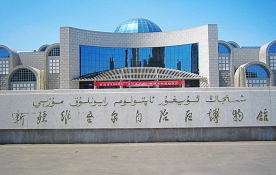
Day 1 Your city-Urumqi
Scheduling
Welcome to Damei Xinjiang! A professional pickup team will arrange the pickup / train to take you to the hotel for rest.If the time allows you to visit the recommended scenic spots by yourself (excluding a separate car).The departure time of the next day will be informed by the driver and the housekeeper with a message or telephone call before 22:00 PM.Please pay attention to check.
Recommended attractions
International bus za
It is a 4A scenic spot integrating characteristic buildings,ethnic commerce,singing and dancing,special food,jewelry and jade and other rich business forms.As a national cultural industry demonstration base and a platform for Xinjiang cultural and creative industry,it has a human flow of more than ten million people every year.It is an important cultural tourism landmark in Urumqi.It has now become a golden name card of Xinjiang cultural tourism,but also a "window to Xinjiang","Window to Central Asia" and "Window to the world".
Hongshan Park
The main red mountain is composed of purple conglomerate,the mountain is ochre red,very unique.In the park,you can walk in the forest,boating on the lake,you can visit the Buddhist temple statues and other cultural buildings,you can experience a variety of amusement projects,when you climb the top of the mountain,you can also overlook the panorama of the city,the content is rich,is a good place to relax in the area,but also a scenic spot for foreign tourists to visit the city.
The park area is not large,the length and width of about 500 meters,after entering can walk.There is a red mountain in the park,about 900 meters above sea level,but the drop with the mountain is only about one hundred or ten meters.There are many trees between the mountain road,and the environment is very good.Climbing here is not tired,and it takes about half an hour.If you lack physical strength,you can also take a sightseeing bus from the mountain to the top of the mountain.
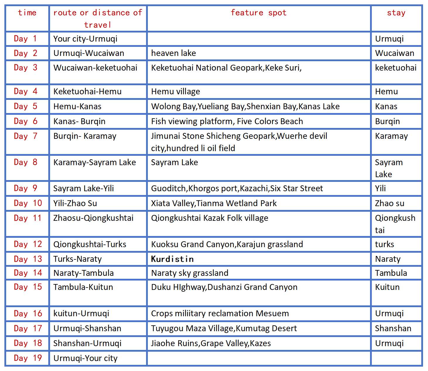
The Xinjiang Uygur Autonomous Region Museum
(No ticket,need to be booked 1-3 days in advance,and the museum is closed every Monday.) It is the first batch of national first-class museums and provincial comprehensive geological museums.It is a cultural relic and specimen collection and protection,scientific research and publicity and education institution in Xinjiang Uygur Autonomous Region.
Recommended entertainment:International Bazaar Buffet Dinner,Silk Road Show,Kunlun engagement,etc
Food recommendation:
Xinjiang cuisine (no Page) chain restaurant: Xiao Gazi,fat old man,Loulan secret roast,Silk Road Date,Hetian rose scratch rice,pomegranate red,Musha barbecue
Special restaurant: lovely Xinjiang (with performance),Toxon 4 noodles,my son lamb,mountain fruit Lane tavern,blood station large plate chicken
Han restaurant: Medical school Li's restaurant,a 30 years old Han restaurant,the store does not accept WeChat,only cash,pig's feet and strange taste cool noodles are the first choice.
In recent years,Urmuqi has opened a lot of delicious Chinese restaurants,such as Xiaomei pigeon Hong Kong restaurant,all kinds of Chaoshan beef hot pot,small Dongting,Hunan Sichuan cuisine and so on.
kindly reminder:
1,Xinjiang is very large,scenic spots between a long drive,tourism is very physical energy,please bring some food or snacks,in case of emergency;
2.There is a two-hour time difference between Xinjiang and inland,breakfast in Xinjiang is around 8-9,lunch around 14 and dinner around 20.For better travel,I hope you can adjust your biological clock to the time difference in Xinjiang as soon as possible;
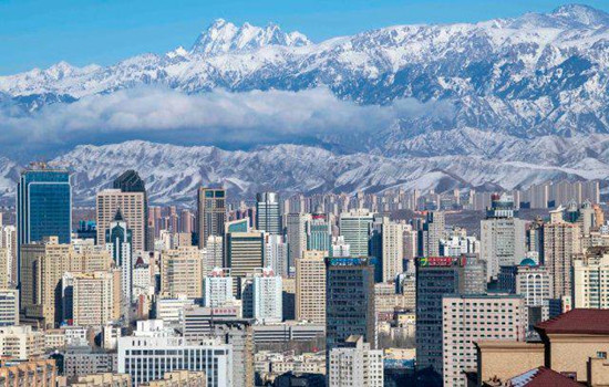
Day 2 Urumqi-Wucaiwan(about 200KM)
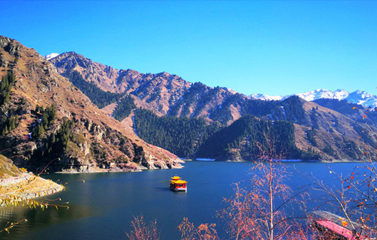
Today's scenic spots:heaven lake
Tianchi has three water levels,in addition to the main lake,there are two water levels on the east and west sides,the east side is the East small Tianchi,ancient Black Dragon Pool,located 500 meters east of Tianchi,legend is the Queen Mother's face.Under the lake for a hundred Zhangs cliff,there are waterfalls flowing down,just like a changhong in accordance with the day,is spectacular,help into a view of the "hanging spring Yao Hong".On the west side is the West small Tianchi,also known as the Jade Girl Pool,which is said to be the place where the West Queen Mother washed her feet,located two kilometers northwest of Tianchi.The lake is shaped like a full moon.The water is clear and deep,surrounded by pine trees.If the bright moon in the sky,static shadow sinks the wall,Qingjing infinite,so also have a scene said: "Longtan green moon".Pool side also fly hanging a waterfall,dozens of meters high,such as the Milky Way landing,spitting beads spattered jade,the scene is called "jade belt silver curtain".There are Wen Tao Pavilion on the pool,pavilion view waterfall interesting.Eyes can see curtain rolling pool Tao,pine tsui water green; The ears can hear the water crashing through the rock and the sound shaking the rift valley.
Scheduling
From the hotel parking lot along the Tu-Wuda highway to Tianshan Tianchi Scenic area.
After getting off at the View parking lot,all visitors must change to the area bus to enter.Every day after 10 am,the district bus stops at Kuokhura Kazakh Folk Village,and all visitors must get off the district bus and walk through the village with the crowd to the next pick-up point.Along the way,there are stalls selling barbecue,naan,ethnic crafts and so on.Then get off at the parking lot at the top of the mountain and walk to the lake for 1.5KM.You can walk or take a scooter.
Drive to Wucaiwan Town,check-in at hotel upon arrival
kindly reminder:
1,the scenic area during the day UV strong,please do sunscreen measures.The temperature of the lake is not high,but the ultraviolet light is very penetrating;
2,Ma Ya mountain top should pay attention to keep warm (2300 meters above sea level) there are few restaurants in the scenic area,and far away from the entrance of the scenic area,so if you want to stay in the scenic area for a long time,you should calculate the time to eat,otherwise you should prepare some dry food with you.
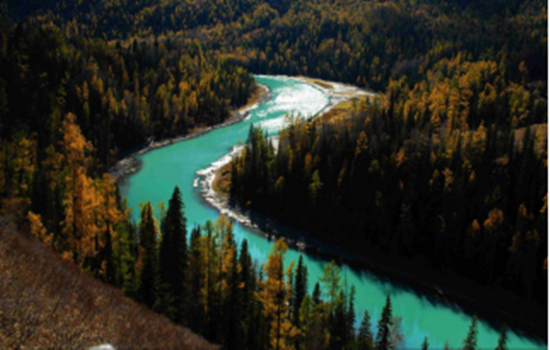
Day 3 Wucaiwan-keketuohai (about 300KM)
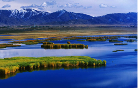
Today's attractions: Coco Suri
It is one of the main scenic spots of Keketuohai National Geopark,23 kilometers away from Fuyun County,Hoh Xil Lake,also known as Wild Duck Lake,with an area of 2677 mu,an average water depth of 2 meters,and more than 20 floating islands formed by staggered reeds in the lake,rich in aquatic plants.
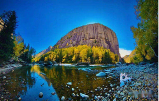
Keketuohai National Geopark
keketuohai Scenic Spot (namely Ertyses Grand Canyon Scenic Spot) is the source of the Ertyses River,a famous river in northern Xinjiang.The scenic spot is about 20 kilometers long,among which there are more than a dozen scenic spots such as birch forest,Shuiditch,Shenzhong Mountain,and hot spring,all along the Ertyses River.There are interval cars in the scenic area,which is a round-trip ticket from the scenic area gate to Shenzhong Mountain (17 kilometers one way).Intercars operate in a way similar to a bus,with a few stops in the middle,tourists get off to visit the surrounding scenic spots and then wait for the next car.There is still 6.5 kilometers away from the hot spring in the deep canyon.You need to go on foot.If you do not have enough physical strength,you can also take the patrol car in the scenic area.
In the gate of the scenic area to Shenzhong Mountain a section of the more key scenic spots are birch forest,water mill ditch,Hongye ditch and Shenzhong Mountain.There are also a lot of strange peaks and rocks along the road,in the middle of the Ertysh River is clear and magnificent,you can have a good play.
Scheduling
Starting from the hotel,along the G216 national Road to Fuyun County,the Gobi scenery is also an indispensable beauty along the way.
Arrive in Cocosuri Scenic area,punch in and take photos,and go to keketuohai Town.
Arrive at Cocato Sea Scenic spot.It takes about 10-15 minutes from the parking lot all the way to the ticket office,and the interval car takes about an hour.Get off at the end of the interval car and return to the original way.There is a battery car beside the bridge below Shenzhong Mountain,and you can walk another 3 kilometers into the canyon.This fee is not included in the interval ticket of the scenic area,so you need to buy a ticket here alone.Do not take the battery car can play in the river,or next to a mountain mountain play.Pay attention to safety along the way.After the original road back to the parking lot to take the interval car to the entrance of the scenic spot.
kindly reminder:
1.Large temperature difference between morning and evening,Take long-sleeved clothes with you.Suitable for light hiking,to wear comfortable shoes;
2.216 national Road speed limit,driving time is long,please bring snacks and fruit;
Day 4 keketuohai-Hemu (about 460 KM)
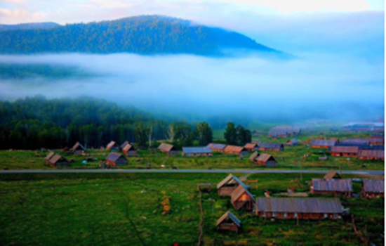
Today's attractions: Hemu
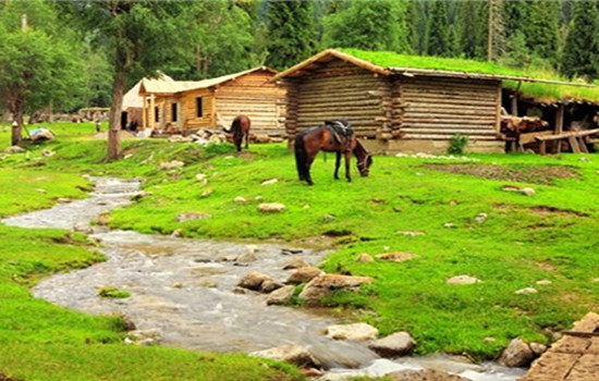
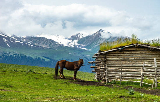
Hemu River flows from northeast to southwest,natural and primitive mountain scenery,primitive village and the prairie harmonious and natural integration.When we come to Hemu Village,the first thing to enter our view is the small cabins and groups of herds,together with snow peaks,forests,grassland,and constitute a unique natural and cultural landscape with blue sky and white clouds.
Its significance is that these cabins have become the symbol of the Tuva people.Most of the cabins are buried in the soil to resist the cold of the snow for nearly half a year,which is particularly primitive and simple,and has the traditional characteristics of nomadic people.The roof is generally nailed with wood adult type canopy,the room body with a diameter of 30 centimeters of 30 or a single layer of log pile,both warm and moisture-proof.
On the hillside around Hemu Village,you can overlook the panoramic view of Hemu Village and Hemu River,view the sunrise,snow peaks and trickle streams,and visit the Tuwa family.It is the best place to shoot the sunrise,morning fog,wooden house and Hemu River.
Scheduling
From the hotel,all the way north to Hemu Village,timely lunch along the way.Along the way,flocks of cattle and sheep,blue sky and white clouds of the grassland,are all people always want to stop involved.
After arriving at the gate of Hemu Scenic area,change the interval car to enter.Although you can not stop to take photos,the scenery outside the window will let people experience the beautiful scenery is always three points in the scenic spots,seven points on the road.
First find the home stay,put down your luggage,you can go to the viewing platform to overlook the whole village.The fastest return time is about 2 hours.You can also enjoy free activities in the river and birch forest to enjoy the lazy leisure time of the wood.
kindly reminder:
1、 On the day of the whole mountain road,carsickness tourists must pay attention to prepare medicine in advance
2、 The scenery along the way to the scenic area is infinitely good.If you need to get off to take photos and punch in,please communicate with the master in advance,and find a safe area to stop before getting off.When you need to cross the road,please pay attention to the passing vehicles and pay attention to the safety on the road.
3、 Due to the remote location of Hemu Village,the prices in the scenic area will be relatively high than those in the city.Please prepare the required items in advance.
4、Hemu Village is mainly wooden homestay or wooden villa,can choose to stay limited,need to have psychological preparation in advance.

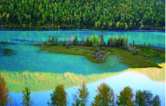
Day 5 Hemu-Kanas (about 100KM)
Today's attractions: Kanas
With the majestic scenery of the north,and the beauty of the Jiangnan landscape,in addition,there are "sea of clouds Buddha light","color lake","float wood long dike","lake monster" and other beautiful scenery,how can not be called the western regions of the beautiful scenery,fairy scenery.To the north is the snow-covered Kuitun Mountain,the towering Friendship Peak.Around the lake,the mountains,the mountains like a painted screen.Different plant communities have distinct layers and different colors.
Scheduling
By interval car into the kanas scenic area,through kanas famous three bay "Shenxian Bay,Yueliang Bay,wolong bay" to the Shenxian Bay water become sparkling,like flashing pearl necklace,then arrived at the Yueliang Bay,overlooking the like a huge footprints in crescent river,and then to wolong bay,like the sword in the Jurassic park,lying in the middle of the river
You can walk in the ancient Kanas Tuwa village,also can go to the Kanas Lake by car,in the peaceful and mysterious,beautiful fairy tale world,temporarily put down the anxiety of city life,meditation eyes,open arms to embrace the quiet and empty here.
kindly reminder:
1,there are many mountain roads,please carsickness tourists must pay attention to prepare carsickness medicine in advance;
2,To enter the Kanas scenic area,you must transfer to the regional car in the scenic area,because the interval car is a cycle,there are many stops along the way,in order to facilitate sightseeing,it is strongly recommended to carry the items needed that night,light to enter the scenic area,large luggage temporarily on their own tourist car;
3, In order to facilitate you to have more tour time in the scenic area,so regardless of the cost of special accommodation in the scenic spot,but due to the poor local infrastructure and environmental requirements,the accommodation conditions in the scenic area are poor,please make psychological preparation in advance;
4,There are still many local residents living in the scenic area,please do not tease cats and dogs,stay away from animals.When communicating with the local residents,please respect the local customs and habits.
5,According to the regulations of the scenic spot,hiking is not allowed,and smoking is not allowed.Please cooperate。
Day 6 Kanas-Burqin (about 180KM)
Today's scenic spot: a fish viewing platform
The fish Pavilion is located on the top of a mountain near the lake,700 meters relative to the lake.It takes about one and a half hours to climb the artificial stone ladder from the lake.After the view of the fish pavilion,there is a dirt road to reach the top of the mountain,but there is no feeling.Part of the fish pavilion hangs in the middle of the summit,but this half is the most critical position to look at Kanas Lake.
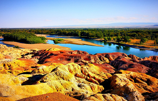
Five Colors Beach
Wucaitan is a national 4A scenic spot.It is located in a dry and windy area.Due to the varying degree of resistance to weathering between the riverbank rock formations,it forms a jagged outline.The rock formations are composed of red,earth red,light yellow and light green sandstone,mudstone and sand conglomerates.It's a typical colored hill.
Scheduling
Go to the transfer center to take the interval bus on the fish platform.On the view of the fish platform,go up the mountain to see the lake,down the mountain to see the scenery,enjoy the highlight of the Kanas central scenic spot!Return from the transfer center to the gate of JiadValley Scenic area,and return to Burqin for the tour bus.After returning to Burqin County go to Wucaitan Scenic area,which is located in the arid and windy area,due to the riverbank rocks。
The strength of weathering resistance is different,forming an uneven outline.The rock layer is composed of red,earth red,light yellow and light green sandstone,mudstone and conglomerate.The rock has different colors,colorful,such as colorful castles,monsters,peaks and other strange landforms,which is a typical colorful hills.When the wind rises,it will make a strange sound,adding a mysterious color.
kindly reminder:
1.Please take your belongings to avoid losing them.
2.The sunset time of the Five Colors Beach varies with the season.If there is no sunset,the weather may not be able to watch the sunset,please prepare psychologically in advance.
Day 7 Burqin-Karamay (about 400KM)
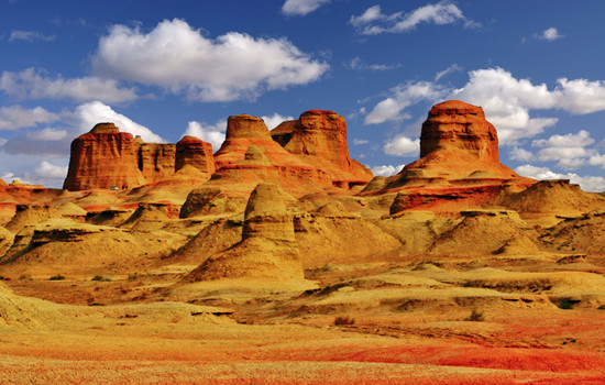
Today's attractions: Urhe Devil's City
Uerhe Devil City,also known as Uerhe Wind City,100 kilometers away from Karamay City,is a unique wind erosion landform,strange shape scenery makes the local Mongols call this "SulumHak".The Uighurs called it "Shayi tank si",which means where the devil lives.In fact,here is a typical Yadan landform area,in the northwest,east and west,the length and width of about more than 5 kilometers,a radius of about 10 square kilometers,the ground is about 350 meters above sea level.
According to investigation,about one hundred million years ago in the Cretaceous,here is a huge freshwater lake,shore with lush plants,water habitat breeding ur wo,plesiosaurs,dinosaurs,junggar pterosaurus and other ancient animals,here is a aquarium gathered "heaven",then after two big crust changes,the lake became sandwiched between sandstone and mudstone land vast,geology called it "gobi platform".
Jimunai Stone Shicheng Geopark
The granite landform in the park is rich and typical,it is a dry area in China,with a large scale and a "god" shape.It is a granite rock egg landform landscape area dominated by wind erosion.It has a variety of micro-landforms,such as granite egg landform,stone egg piling landform,stone mound,stone cave,stone cave,stone basin,stone forest,stone column,stone trough,cliff and so on,and can be called the museum of granite wind erosion landform.
Scheduling
To Jimu is Shenshi City Geopark,the park not only has mysterious grassland stone figures,there are many different forms of granite landforms,is currently rare in the northern Xinjiang minority scenic spots.Arrange lunch in real time.
Wulhe Devil City,enjoy Yadan landform,naturally formed a variety of pictographic attractions,three points by looking,seven points by thinking.
Along the G217 National Highway to Karamay,passing the Baili Oil Field observation platform in the Baialkali Beach District,you can see the dense oil extraction machines standing in the vast Gobi Beach,as if entering the movie scene of a science and technology blockbuster.
kindly reminder:
1,Ulhe Devil City year-round wind,hot summer,has avoided the midday sun,but the climate is dry,pay attention to sunscreen,water; Please prepare for sun protection and heat protection in advance.
2,Baili Oilfield observation platform for oil field production area,no fireworks.
Day 8 Karamay-Sayram Lake (about 350KM)
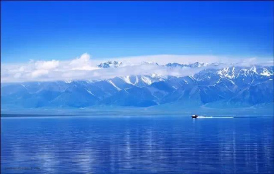
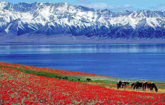
Today's attractions: Sayram Lake
Sayram Lake,known called "Net Sea",is located in the North Tianshan Mountains in Bole City,Xinjiang Province,close to Huocheng County,Yili Kazak Autonomous Prefecture.The lake is 2071 meters above sea level,30 kilometers long from east to west,25 kilometers wide from north to south,an area of 453 square kilometers,the water storage capacity of 21 billion cubic meters,the water is clear and transparent to 12 meters.
Scheduling
Follow the G30 expressway to Sayram Lake ,arrange lunch in the east gate service area of the scenic area.You can take photos and punch in the Sayram Lake scenic area,stop and enjoy the leisurely time.Summer cerimu Lake wild flowers in full bloom,you can sit on the ground by the lake and meditate,you can also ride on the grassland.At this moment,time can stay in the camera,can also quietly disappear in the casual laughter.
kindly reminder:
1.Sayram Lake has a high altitude and the weather changes quickly.Please prepare sunscreen,wind and cold prevention equipment in advance.
2.The scenic area is located in a remote area,with high prices and accommodation conditions are limited.Please make psychological equipment in advance.
Day 9 Sayram Lake -Yili (about 150KM)
Today's scenic spot:
Khorgos port
Khorgos port is the longest national first-class land road port with the largest comprehensive traffic volume,the best natural environment and the most complete functions in the history of western China.
As early as in the Sui and Tang Dynasties,Horgos was an important post station on the New North Road of the Silk Road and an important channel for transportation in the Western regions.In the seventh year of Guangxu (1881),China and Russia signed the constitution of Land Trade,and Khorgos became the official treaty port between China and Russia.
Kazanqi folk tourist area
Kazanqi Folk Tourism Area in Yili City is the only large original ecological cultural scenic spot in northern Xinjiang with Uygur ethnic customs as the main body,because it is the window of the image of Yili city,but also the true portrayal of ethnic customs,which covers the thick Uygur culture,without losing the unique customs and feelings of the Uygur ethnic group in northern Xinjiang.
For foreign tourists,Kazan is enough to meet their aspirations of "running in the city by carriage" and "feeling the ancient traditional folk culture in the modern city".Here,the original Uyghur traditional way of life is still preserved: the antique Uyghur people's residence; A poetic bridge running water; Tall and simple poplars can be seen everywhere; Mellow milk tea,exquisite pastries; Classical,traditional and lively Uyghur wedding; Wild,cheerful,passionate Macilef...
Scheduling
Through the first scene of Yili - fruit Ditch,on the way you can enjoy the fruit Ditch bridge built between the mountains
After arriving at the Khorgos port,the Old gate scenic area punched the boundary tablets of China and Tsarist Russia during the Qing Dynasty.After that,you can apply for a pass to enter the duty-free zone and punch in,where there are not only many goods exported from China,but also special goods from other Central Asian countries such as Kazakhstan.
The characteristic Uyghur traditional architecture in Kazanqi Folk Tourism Area of Yili City is not only to experience different folk customs,but also to enjoy many special foods waiting for you!
In recent years,the Liuxing Street in Yili City has witnessed the strange cultural symbiosis phenomenon of the combination of foreign culture and local culture.
kindly reminder:
1,Guogou Bridge is the only place on the way,the bridge can not stop,can only drive slowly slowly experience the steep here;
2.There are many goods in the duty-free area of Khorgos port,which is not a shopping store.
About lavender viewing
3.Every year from mid-June to mid-July is the lavender blooming season,the flower season we will specially arrange to go to the lavender flower field today to take photos and watch,to meet your yearning and love for lavender;
4.Smokey base for free scenic spots,do not go to no refund,the flower season will be automatically cancelled,without any cost increase or decrease,please know;
5.Due to the visit to the lavender base,today's travel time node will be slightly adjusted according to the actual situation.
Day 10 Yili-Zhao Su(about 300KM)
Today's attractions: The Xiata Valley
In ancient times,it was a transportation post from Yili to Aksu.The Shata River flowed out from the mountains,opened the flat grassland and flowing into the vast Teks River.Shata Canyon to the river by the mountain pass,ancient road,ancient sites,folk customs and natural landscape,formed an ancient cultural landscape.It is also known as the Tang Monk Ancient Road,and it is said that this is the famous "Gongyue Road" of the Tang Dynasty.The "Ling Mountain" that Tang Xuanzang crossed to the west is here.It is the most precipitous passage on the Silk Road.Along the canyon,it is the remains of the ancient road.
Tianma Wetland Park
Located in the Zhaosu River Basin,it is the largest natural wetland in Xinjiang and the largest wetland park in northwest China,covering an area of nearly 5,000 hectares.There are various types of wetlands,including swamps,lakes,rivers,etc.The wetlands have rich natural resources and unique ecological environment.And it is known by visitors,in the scenic area of the "Tianma bath River" performance.
This characteristic continues to this day,Zhaosu County is known as "the hometown of Tianma in China" because of its rich "Tenglun,western pole" horses.Every summer,herdsmen will bring their horses to the Tekes River every day to drink water and run.As time goes by,"Tianma Bath River" has become a unique scenery in the wetland park.
Scheduling
Crossed the Tianshan Canyon along the way,and deeply felt the many canyon scenery of the Yili Valley.
Arrive at the Shata Scenic area,and transfer to the Shata Canyon.The primeval forest deep in the Tianshan Mountains and the mountain grassland are a unique scenery.
The "Tianma Bath River" performance in Tianma Wetland Park will be a special web celebrity punching place for many visitors to visit.
kindly reminder:
1.The interval cars in Shata Scenic Spot are circular trains,and electronic tickets need to be booked in advance in peak season.
2.The Tianma Bath River performance should control the time of arrival at the park.It may be impossible to watch the performance due to objective reasons such as weather changes and missing the performance time.
Day 11 Zhaosu-Qiongkushtai (about 170KM)
Today's attractions: Qiongkushtai
Qiongkushtai is a pastoral village with more than 300 households and more than 1,700 people,and the village residents are mainly Kazakh.The village is surrounded by mountains,the houses are built by water,and the Courdai River flows all the year round.The buildings of the village are mostly round wooden structure,which is a well-preserved wooden building complex in the Ili River Valley.It has high historical and cultural value and is gradually attracting more tourists to travel for vacation.
Scheduling
On the way to Qiongkushtai,the alpine meadow and grassland under the blue sky and white clouds are all the beauty of the computer desktop.You can stroll around the village,or ride horses or go to the Wusun Ancient Road.Even staying quietly in the wooden house is a quiet enjoyment。
kindly reminder:
1.Qiongkushtai Folk Village was originally a fixed residence of Kazakh ethnic compatriots.The wooden houses and homestay here are similar to those of Hemu Village,and the living environment is far from that of the city.
2.If you need to ride along the Wusun Ancient Road,please choose the regular horse team in the village.
Day 12 Qiongkushtai -Tekes (about 100KM)
Today's attractions: Karajun
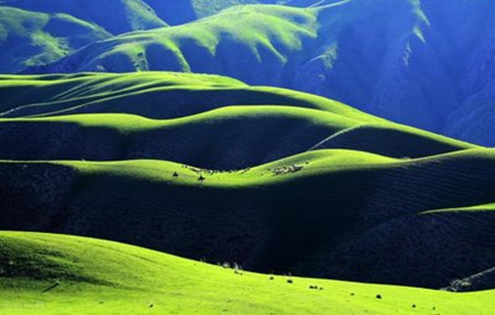
"Karajun" is a Kazakh language that means "the wilderness on the ridge".Kaljun mountain is a east-west rolling mountain,it is flanked by the gully comb mountain,ups and downs,the growth of dense primitive spruce forest.Between 2000 and 3600 meters above sea level,it is an alpine meadow grassland,which is about 25 kilometers wide from north to south and more than 40 kilometers long from east to west,with a total area of more than 1000 square kilometers.It is the most beautiful area of Tianshan grassland,completely retaining the original and pure natural appearance,grassland and forest blend,snow peaks and valley reflect,the scenery is very spectacular,showing the original beauty of snow ridge spruce.
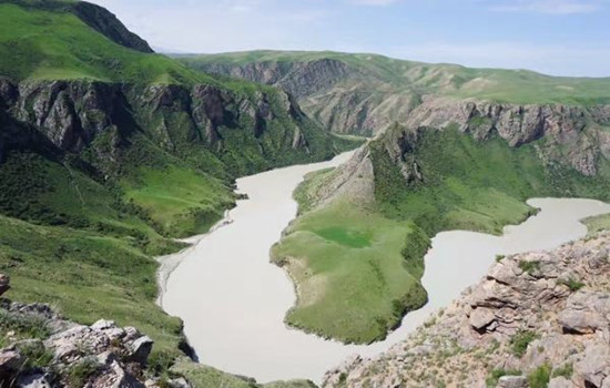
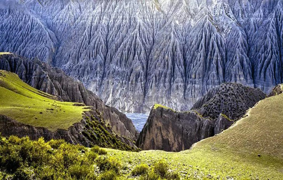
Khoksu Grand Canyon
The Kuoksu River twists and turns,forming the nine curves of over 5,600 meters long from north to south and more than 2,000 meters wide from east to west.Herdsmen's yurts are dotted with them,gorge scenery,waterscape,mountain scenery,tree scenery and other natural landscape,full of fun.
Scheduling
Kuoksu Grand Canyon includes Jiuqu Eighteen Bay,Kuoksu Grand Canyon and Crocodile Bay,and finally from the Kurdai River cableway into the Kaljun Grassland Scenic Spot.
Transfer to the interval bus and start to visit the Karajun scenic area.The flower platform is an excellent place to enjoy the beautiful scenery of the grassland.After getting off the bus,climb uphill along the plank road.Although it is a little laborious,you can see the snow mountains,forests,flowers and grasslands here,and you can also take photos with the lamb.Falcon platform: a traditional hawk place for local people.After getting off the bus,it is recommended to go about 1 km along the plank road (also on horseback),overlooking the "three-level level plane" and forest canyon.
After staying at Tekes County Hotel.You can also go out of the scenic spot in advance to the exit street and Bagua Park in Tekes County,and feel the many marks of the I Ching culture in this characteristic county。
kindly reminder:
1.The interval car circulation system in the scenic area,so please listen to the master explain whether to get off at each stop.
2,each stop has a canteen,only in the ropeway station below a restaurant can eat on the way.
Day 13 Tekes-Naraty (about 300KM)
Today's attraction: Kurdishtin
Kurdistin is the Kazakh word for horizontal ditch.The grassland scenic spots in Yili are located in the east-west river valley,but Kurdistin is in a north-south mountain wide valley,about 14 kilometers long,the widest point is about 1 kilometers,the average elevation of the bottom 1,500 meters.The special trend makes Kurdistin warm in winter and cool in summer and pleasant in four seasons,so it has both the charm and beauty of Jiangnan mountain villages and the broad and rough grassland scenery,attracting more and more domestic and foreign tourists.Her stunning sky and otherworldly natural landscape are breathtaking and make people yearn for it.
Scheduling
Kurdistin scenic area also has many regional car parking points,according to the actual situation depending on the length of each scenic spot.Choose the dining place in real time in the scenic spot,you can also bring your own dry food to enter the scenic spot
kindly reminder:
1,the mountain area changes the weather changes fast,always pay attention to the weather changes and decide the stay time.
2,winding mountain road is more,please prepare motion sickness medicine in advance.
Day 14 Naraty-Tambula(about 100KM)
Today's attraction: Naraty
Naraty tourist scenic spot integrates grassland,valley and forest,with high vegetation coverage rate and rich wildlife resources.Because of its unique natural ecological landscape and cultural landscape,it is known as "Tianshan Green Island","green home" and "colorful grassland".The main scenic spots are Tianjie Platform,nomadic family,Tusani (meaning "beautiful valley" in Kazakh),Sendai,Wall Tower observation platform,Snow Lotus Valley and so on.
Scheduling
Enter the Naraty grassland scenic area,looking for the rich beauty of the beekeeping women.You can overlook the beauty of the whole valley grassland,but also go to the snow lotus valley and snow mountain close contact,feel the cool summer.
kindly reminder:
1.For example,under the opening of duku Highway in summer,take the middle section of duku Highway G217 to Naraty town.
2.Nalati Airland Grassland is located in a mountainous area,please always be ready to add clothes.
Day 15 Tambula-Kuitun (about 260KM)
Today's scenic spot:
Duku highway
Also called Tianshan Highway,is a section of national Highway 217,more than 300 kilometers away from Urumqi,located in the middle of the Tianshan Mountains,north-south trend,from Dushanzi in the north to Kuqa in the south,a total length of 561 kilometers.Before the opening of the Dukuku Highway,there was only one road connecting the southern and northern Xinjiang,from Dushanzi to Kuqa,you need to detour Urumqi for more than 1,000 kilometers,and the Dukuku highway saves nearly half of the journey.More than 280 kilometers of the road are above 2,000 meters above sea level.It is not an ordinary road,it is a miracle road,it crosses the four year-round snow mouth,crosses nearly 10 major rivers in the Tianshan Mountains,1/3 of the road is full of steep cliffs,and 1/5 of the road is underground in the alpine permafrost.It is a milestone in the history of highway construction in China.Buddha Caves
Dushanzi Grand Canyon
In Dushanzi,Kuitun River flows through the Dushanzi Grand Canyon,the canyon is nearly north-south,the valley wall cliffs are steep,the valley bottom water is at the same time,the shoulder ground is desert grassland,standing on the shoulder to look at the canyon,presented in front of a typical Grand Canyon scene.These extraordinary landscapes are carved into the walls of the valley by alluvial gullies formed by snow and rainwater flowing down the Tianshan Mountains through the soil.The valley begins at the foot of the mountain and forms distinct layers of soil on the grassland.But the color is mainly grey and black.The snow in the canyon is heavy,but as it passes through the soil,the water becomes muddy,carrying sediment with it.
Scheduling
The scenery along the northern section of the Duku Highway was exchanged by heroes with sweat and blood.Walking on such a red road,experience a special landscape of "one mountain has four seasons and ten miles of different days".
Dushanzi Grand Canyon is 100-400 meters wide at the valley floor,800-1000 meters wide at the valley shoulder,and up to 200 meters high from the valley floor to the valley shoulder.Once honored by National Geographic magazine,the first view of the most beautiful highway in the country,
kindly reminder
1,the whole road is a mountain road,the asphalt road is relatively flat,because of the bend and narrow road,more uphill and downhill,friends who have the habit of motion sickness should prepare motion sickness drugs in advance;
2,driving in the mountain road high risk factor,the master will stop at a safe parking point for photos;
3,some sections of the Duku highway up to 3,000 meters above sea level,the temperature drops,please prepare thick clothes in advance.
Day 16 Kuitun-Urmuqi (about 300KM)
Today's scenic spot:
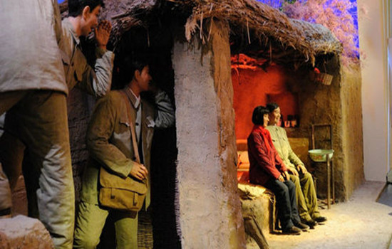
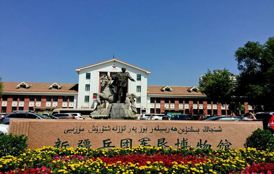
Corps military reclamation Museum
Located in Shihezi City,it is a special museum reflecting the history and development of military reclamation of Xinjiang Production and Construction Corps.Through numerous cultural relics,picture descriptions show the ancient history of Shihezi,the history of military reclamation and subsequent development,etc.,is a good place to understand the history of the production and construction corps.
Premier Zhou Memorial Hall
In the northern suburb of Shihezi City,3 kilometers from the city center.The south side of the monument is the Prime Minister's Memorial Hall,and the north side is the memorial Hall.The inscription on the south side is the inscription of Premier Zhou's inspection of the Corps in 1965,the inscription on the north side is an excerpt of the government work report made by Premier Zhou at the Third National People's Congress,and the inscription on the back is the inscription of the construction.Overall view of the monument,tall and tall,dignified shape,simple and vigorous style,the flowers and pines in front of the monument,giving people a mild and serious sense.
Scheduling
Arrived in Xinjiang's garden city - Shihezi City,visit the Corps military reclamation museum,through a large number of cultural relics,picture captives show the ancient history of Shihezi,military reclamation monument,is also a local red patriotism education base.
kindly reminder:
If the museum is closed on Monday,this view will be cancelled.
Day 17 Urmuqi-Shanshan (about 300KM)
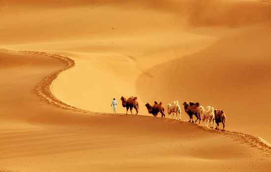
Today's attractions: Kumutag Desert
Kumtag Desert,covering an area of 2,500 square kilometers,is located at the southern end of Shanshan Old Town,Xinjiang Province,which is one of the few deserts in the world that has close contact with cities.It is characterized by complete sand landforms,clear outline and distinct layers of sand dunes.Kumtag means "sand mountain" in Uyghur language,and Kumtag Desert is "desert with sand mountain".
Library wood tower desert mainly because from tianshan seventeen well tuyere southwest wind and daban city tuyere southeast wind,along the changfeng journey,with a lot of sand,finally meet in library wood tower area collision and deposition,south of cook tag mountain also contributed to two directions of wind weakening and sand deposition,forming "sand mountain desert" the unique landscape.Therefore,the Kumtag Desert has become a scenic spot integrating scientific research,investigation,exploration,sand sports,sand therapy and health care,and desert sightseeing.The temperature difference between day and night in the sand mountain is large.In midsummer,the surface sand temperature is 70℃,and the highest is 82.3℃.The eggs can be buried in the sand.
Tuyugou Maza Village
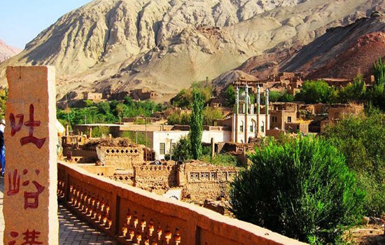
Maza Village belongs to the climate zone south of the Flaming Mountain.It is a historical and cultural ancient village integrating human landscape and natural landscape,Buddhist culture and Western culture.With a history of more than 2,600 years,Mazha Village is a typical representative of the village pattern under the Islamic cultural background in eastern Xinjiang,showing the traditional Uygur style of "ancient villages,ancient houses,ancient alleys and ancient trees".There is Tuyugou Grottoes,a national key cultural relic protection unit,in the north of Mazha Village,and Huojiamu Maza in the west.A large number of traditional houses built with raw soil are preserved in the village,which is a model of raw soil architecture in Xinjiang and is known as "the first soil village in China".
Scheduling
The Kumtag Desert scenic area in Shanshan County.On the golden sand mountain,you can see the long yellow sand and rolling sand ridge,connected with the sky,giving people a vast,magnificent,solemn and profound feeling.Standing at the junction of the oasis and the desert,watching the square scenery,the strange scenery in front of the amazing: one side is the vast,vigorous,boundless desert ocean; the other side is the lush,beautiful and charming oasis green wild.This is the outstanding nature of nature,there is no transition between yellow and green,but the two colors form a sharp contrast,just like the painter's color plate,yellow and green,strong contrast and harmonious unity,it is amazing.
The Maza Village in Tuyugou is surrounded by mountains and built by oasis.The Subexi River runs through the village,connecting six clusters.Village cultivated land is near the water distribution,residential houses and cultivated land depend on each other,living near the water.The residential houses are built on the platform between the slope,which are 30 to 50 groups with the terrain,scattered and integrated into the environment,and the reasonable result of the slope valley terrain and the desert Gobi terrain and climate facing the sun.
kindly reminder:
1,Turpan perennial drought and less rain,pay attention to small drink water,heat and sun protection
2,Jiaohe old city is a cultural relic site,do not take photos on the plank road or climb to the earth wall to take photos,pay attention to the protection of cultural relics!
3,enter the desert scenic area to pay attention to your belongings,small items must be collected in advance,similar to bracelets,necklaces,rings and other valuable jewelry fell into the sand,it is difficult to find back.
4.If you want to make some videos like the ethereal air,then the red skirts and scarves must be ready.Silk scarf is the best god in the desert collocation.The silk scarf at the gate of the scenic spot is 35 yuan each.Choose the white or red silk scarf.
Day 18 Shanshan-Urmuqi (about 300KM)
Today's attractions: Jiaohe Ruins
Jiaohe city site,located in turpan city about 13 kilometers west of Yar township,the western suburb of Turpan city 10 kilometers eraizi ditch two rivers intersection 30 meters high loess platform,about 1650 meters long,both ends narrow,the widest about 300 meters,is a willow leaf shaped peninsula.It is the capital of the former state of the state of the ancient Western Regions,and is the political,economic,military and cultural center of the country.The drought and little rain in Turpan made the old city very complete.The buildings are all made of rammed earth plates,and the shape and layout are similar to that of Chang'an City in the Tang Dynasty.In the city,streets,offices,temples,stupas,streets,workshops,dwellings,performance fields,Tibetan trenches,temples and temples can also be found.The temple covers an area of 5,000 square meters,with a large water well.The pagoda group has 101 stupas.Looking down from the air,the Jiaohe old city looks like a big willow leaf.
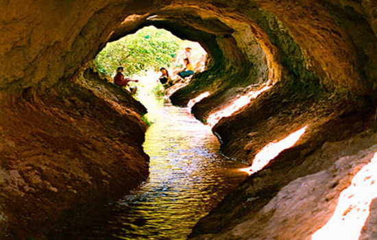
karez
Karez is a kind of underground water conservancy project created in the long historical development of the working people in the arid land.The karez drew out the groundwater,turning the desert into an oasis,called the "well canal" in ancient times.The main working principle of karez is that people use a large amount of rainwater,glaciers and snow melt water seeping into the ground in spring and summer by using the natural slope of the mountain to draw out the surface for irrigation,so as to meet the demand of production and living water in desert areas.Karez in different regions have different regional characteristics in specific structure,but generally speaking,a complete karez system includes four main components: shaft,culvert (underground channel),open channel (ground channel) and fault occurrence (small reservoir).Under this principle,the flow of the arez is stable and the irrigation of well water can be guaranteed.
Grape Valley
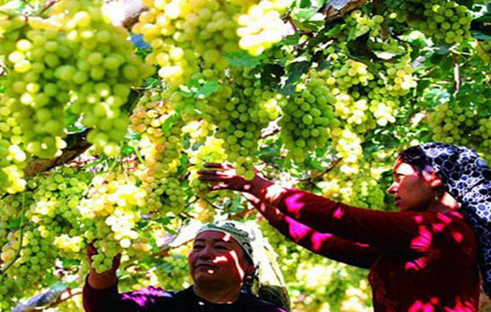
The scenic grape Valley is famous for its high-quality grapes.Here by the mountain next to the water,quiet,elegant,scenery,several grape corridor deep,quiet,some tourists walk under the grape frame,look up to enjoy the taste of pearl-like grapes,some visitors sit under the grape frame taste fresh grapes.The three bright red characters on the stone at the end of the long corridor are particularly eye-catching,and visitors rush to take photos here.
Scheduling
After arriving in Turpan,visit Jiaohe City and have lunch in Turpan City.
On both sides of the grape valley stream,the grape racks are all over,and the vines are stacked and green.All around is a dense aspen forest dotted with flowers and fruit trees,and farmhouses are arranged on gentle slopes.In the summer is a rare summer place in Turpan.Grape Valley is a rare summer place in Turpan in the middle of summer.
With a history of more than two thousand years,the Karez,as the source of life for the Turpan people,is an indispensable scenic spot on this trip!
kindly reminder:
1,Turpan perennial drought and less rain,pay attention to small drink water,heat and sun protection
Day 19 Urumqi-Your city
Arrange the flight / station according to the flight / train information,end the deep journey of northern Xinjiang,return to the warm home! Welcome to visit Xinjiang again!
The trip time node is for reference only,subject to the actual participants